Photos | Mapping Out San Francisco
A detailed plan of the city of San Francisco sits atop a table, highlighting its streets and neighborhoods. Artfully designed, it serves as both a document and a work of art.
BLIP-2 Description:
a map of the city of san francisco is displayed on a tableChronologically Adjacent
Note: You can also navigate with your arrow keys or swiping.
Metadata
Capture date:
Original Dimensions:
3024w x 4032h - (download 4k)
Usage
Dominant Color:
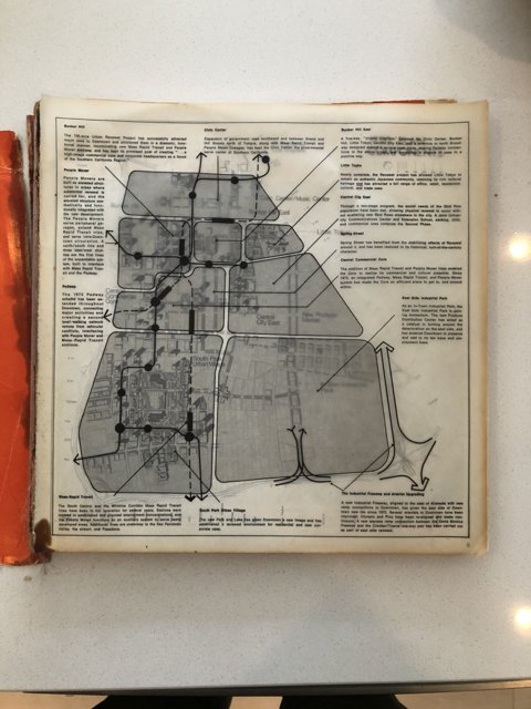
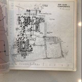
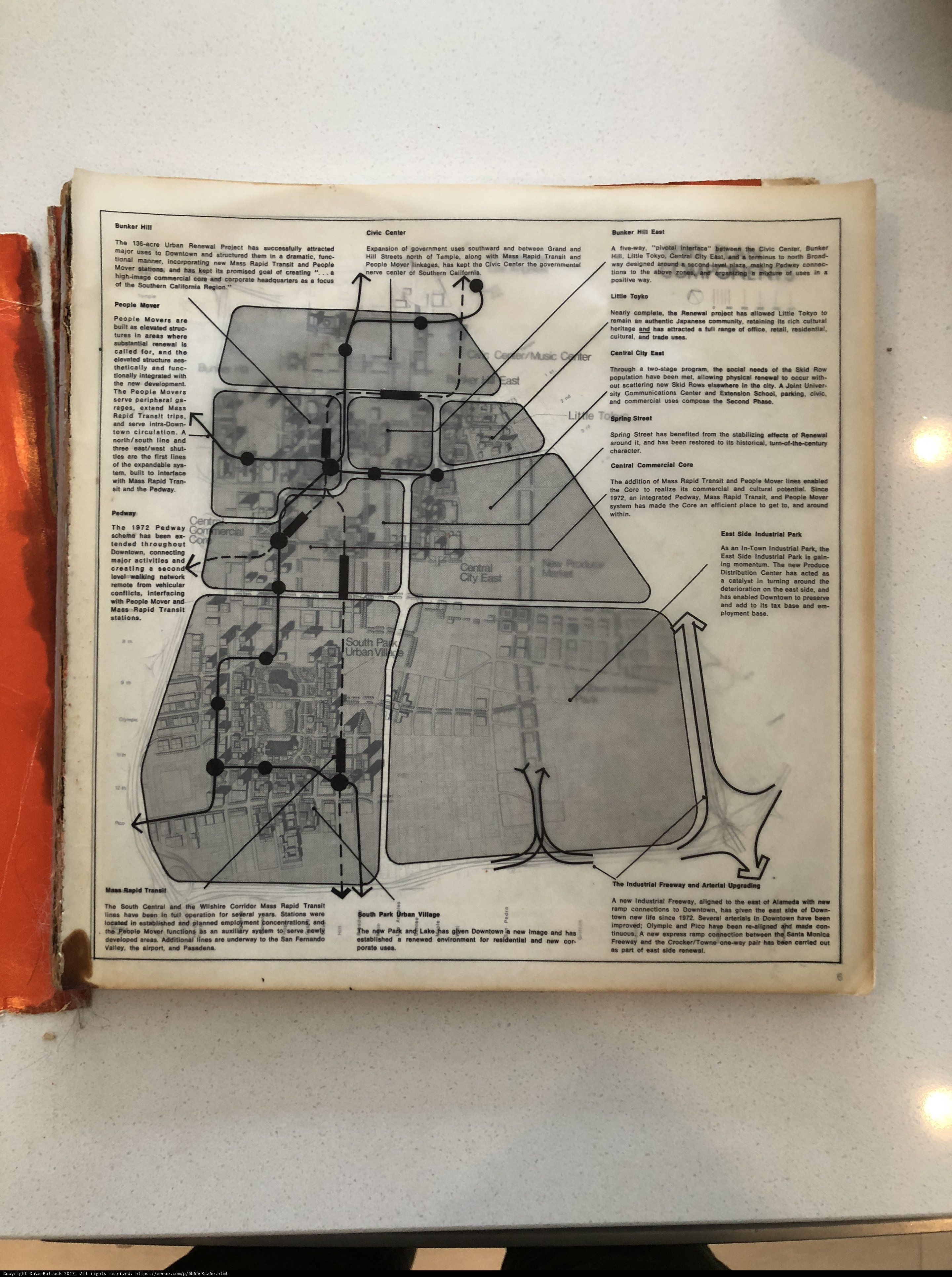
urban pedway produce civic major plan focus nearly get park tional wilshire renewal underway document acre place airport outween remando crocker structured arterial movers incorporating residential wass complete core toyko streets soutwaro sout con high tablished century lako text retaining adortional tran tunawal art hill gain california north successfully hin potentra rapid norn upgra areas distribution alameda environment renewed integrated expansion built project valley tax benefited southern diagram years lines realize planned freeway napid porate aligned elevated san maas downtown pair system retail ons mass functions tunc soverment attracted kept restored turning base enabled plot employment tokyo mover south several certal drawing new goal since rich transit established around carried linkages authentic japanese way allowed coldlyst concentrations ployment towne headquarters five addition line little creati remain image auxiliary historical center east nerve stations temple tull map made side operation chart ne dramatic promised one stabllizing street ns grangand acted town corporate commercial bunker turn along efficient pasadena uses industrial community city full stati serve glven region range cultural deterioration governmental village central ang office spring effects newly manner pan cuntural life cor add corridor arterials
Detected Text
136 1972 acre allowed authentic adortional airport alameda arterial as auxiliary bunker base built central century city con cor corporate corridor california center civic commercial complete crocker cultural distribution deterioration downtown effects efficient elevated enabled expansion east established functions focus get gain hill hin historical integrated its image industrial japanese kept lako life lines little maas made mass mover movers ne nearly newly pair produce pan pasadena pedway people place project retail retaining range rapid renewal rich serve sout stati san south southern spring street tokyo turning temple town towne toyko tran transit tull turn underway urban upgra valley way wilshire years a acted add addition aligned along an and ang are areas around arterials attracted been benefited carried certal coldlyst community concentrations core creati cuntural dramatic employment environment five for freeway from full glven goal governmental grangand had has have headquarters high in incorporating is it line linkages major manner napid nerve new norn north ns of office on one ons operation or out outween park planned ployment porate potentra promised realize region remain remando renewed residential restored s several side since soutwaro soverment stabllizing stations streets structured successfully system tablished tax the them tional to tunawal tunc uses village wass were with
iso
50
metering mode
5
aperture
f/1.8
focal length
4mm
shutter speed
1/15s
camera make
Apple
camera model
lens model
overall
(21.24%)
curation
(25.00%)
highlight visibility
(1.99%)
behavioral
(10.09%)
failure
(-0.32%)
harmonious color
(4.09%)
immersiveness
(0.34%)
interaction
(1.00%)
interesting subject
(-54.15%)
intrusive object presence
(-12.45%)
lively color
(14.77%)
low light
(0.29%)
noise
(-2.42%)
pleasant camera tilt
(-5.06%)
pleasant composition
(-6.80%)
pleasant lighting
(17.33%)
pleasant pattern
(5.42%)
pleasant perspective
(14.83%)
pleasant post processing
(9.81%)
pleasant reflection
(-7.17%)
pleasant symmetry
(1.88%)
sharply focused subject
(2.56%)
tastefully blurred
(-4.91%)
well chosen subject
(12.13%)
well framed subject
(40.09%)
well timed shot
(-0.30%)
all
(6.13%)
* WARNING: The title and caption of this image were generated by an AI LLM (gpt-3.5-turbo-0301
from
OpenAI)
based on a
BLIP-2 image-to-text labeling, tags,
location,
people
and album metadata from the image and are
potentially inaccurate, often hilariously so. If you'd like me to adjust anything,
just reach out.